Frequently Asked Questions
If you cannot find the answer to your question below, please email [email protected].
General
- Do I need to do anything before I deploy tags?
- What is the shelf-life of a tag?
- How long will a tag last?
- What is the lead-time for tag orders?
- How do I see my data?
- I will also be using a VHF tag, will this interfere with the SMRU tag?
ARGOS
- How do I get started with Argos?
- How much does Argos charge?
- How should my PTT numbers be configured?
- Argos have sent me a “Request for ARGOS ID’s” form…
Data interpretation
- What do the various columns in the database contain?
- How do I calculate the TAD index for a dive?
- Can you add sunrise and sunset columns to the haulout/CTD table?
- The summary data says there are no dives, but there are average depths and durations, why?
General
Do I need to do anything before I deploy tags?
It’s a really good idea to switch on the tags and allow them to transmit overnight. This helps the Argos system to recalibrate to the new location, and allows us to verify that all is working well before the tags are deployed. Ideally the tags should be spread out on a flat roof with a clear view of the sky. For Gen 1 SRDL variants, there are detailed instructions here.
What is the shelf-life of a tag?
Tags are shipped in standby mode and use very little energy in this state. Approximately 5% of the total capacity is lost each year.
How long will a tag last?
Typical deployment times are 12 months for SRDL’s and CTD’s, 6-9 months for GPS phone tags. However, a major feature of SMRU tags is the ability to match their behaviour to user requirements.
Argos transmissions are the main energy user for SRDL’s. We can vary the transmission rate by setting a number of targets to be achieved through the deployment: it is often useful to set a high rate at the beginning of the deployment (to get a high-quality dataset “in the bank”) and then progressively to reduce the rate to try to extend the lifetime as much as possible. This means that two-year or three-year deployments are achievable for turtles, for example.
For CTD tags, the energy consumed by making samples becomes significant. There is a tradeoff between collecting data and relaying it: there is no point collecting data that can’t be sent, but excessive transmissions could compromise sampling rate. We use a model that combines energy costs with the probability of successful transmission at given latitude. This allows us to calculate the sampling rate that maximises the expectation of total amount of data received for a given deployment.
The GSM modem used by GPS phone tags is so much more efficient than satellite comms that energy used to transfer data becomes insignificant. The main determinant of tag lifetime is the frequency of GPS fix attempts.
| Interval between fix attempts | Expected tag lifetime |
|---|---|
| 3 mins | 6 months |
| 5 mins | 8 months |
| 10 mins | 11 months |
What is the lead-time for tag orders?
The lead time usually varies from 6-12 weeks, but we may well already have the correct tags in stock. Please contact us for up-to-date information.
How do I see my data?
Our computers make regular connections to Argos on your behalf. There is usually a lag of about 2 hours between a message reaching the satellite and it being available for download from Argos. Any new transmissions are decoded and the data collated. Your private webpages are then prepared, showing a snapshot of the latest data and an overview of the whole deployment. These typically update every 6-12 hours.
I will also be using a VHF tag, will this interfere with the SMRU tag?
We have not experienced any problems with this setup.
ARGOS
How do I get started with Argos?
The Argos satellite tracking system is administered by an organisation called CLS. Their main offices are in Toulouse, France and Maryland, USA. Contact the CLS Argos User Office and explain that you wish to track marine animals with SMRU tags. Environmental use of the system by governmental or non-profit users is covered by a special agreement known as the Joint Tariff Agreement (JTA). CLS will send you a System Use Agreement form to confirm that you are eligible for the JTA (which you almost certainly are). They should also inform you of a local representative who is familiar with the system.
Having been accepted under the JTA you should then receive a purchase order form. Once this has been processed you can then request a PTT number for each of the tags that you are planning to deploy. The PTT number is the equivalent of a phone number – it uniquely identifies the transmissions made by each device.
How much does Argos charge?
Under the JTA there is a fee of €15 for each calendar month in which the tag transmits. In addition there is a usage charge of €7.50 per day.
A reduced tariff was introduced in 2008 that recognises the limited demands that animal tags place on the system. This caps the usage charge at 12 days per month, making the maximum monthly charge €105 (i.e. €15 + 12 x €7.50).
Usage is calculated in increments of 1/4 day (00h-06h, 06h-12h, 12h-18h, 18h-24h UTC). A €1.875 charge is made for each 1/4 day period in which two or more uplinks are received. Tags try to transmit whenever they have the opportunity, so for budgetting purposes it should be expected that a tag will reach the 12-day cap each month, costing €105.
How should my PTT numbers be configured?
- Multi-satellite service
called Location Service Plus in Europe, Auxiliary Location Processing in North America - Repetition rate: 40 seconds
- 31 x 8-bit sensors (32 x 8-bit for old-style PTT numbers below 32768)
SMRU tags use the full Argos message. PTT numbers which have previously been used for other tags may not be set correctly. - Type A2(hex) processing
Type A2(hex) is our preferred format, but we can also collect data in A1(decimal) format. It is preferable to keep the same format for all PTT’s in a programme, so if you already have some decimal PTT’s it is best to stick to decimal for your SMRU tags.
Argos have sent me a “Request for ARGOS ID’s” form…
These are answers to some of the more obscure questions:
- Manufacturer: Sea Mammal Research Unit
- Transmitter Model: TWIC
- Transmitter Power: 0.5 W
- Message Length: 248 bits
- Technical File: 31 x 8-bits Hexa(A2)
- Transmission Cycle: None
- Repetition rate: 45 secs
Data interpretation
What do the various columns in the database contain?
This PDF document provides a brief description of each field.
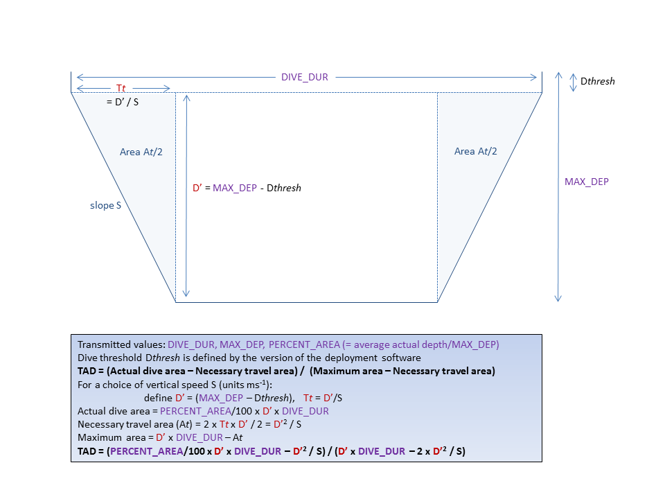
How do I calculate the TAD index for a dive?
Can you add sunrise and sunset columns to the haulout/CTD table?
In the downloaded database there are three functions called sun_rise, sun_set and sun_alt. These calculate the sun’s position for any latitude, longitude and time.
In the “Query” section you will find “sun_example”, which shows how to use these functions to find the altitude of the sun and the sunrise/sunset times based on the mid-point of each haulout.
If you just want to fill in the missing columns in the dive table, make a new query, switch to “SQL view” and enter this:
UPDATE dive SET sunset=sun_set(de_date,lat,lon),sunrise=sun_rise(de_date,lat,lon)
The summary data says there are no dives, but there are average depths and durations, why?
Data must be heavily compressed for transmission. This means that a single transmitted value can represent a range of true values. At the decoding stage we follow the convention that the value stored in database is the lower bound of this range.
As an extreme example: the number of dives might be transmitted in units of 10. So all true values 0..9 are transmitted as code 0, values 10..19 are transmitted as code 1, 20..29 are transmitted as code 2 etc. When the transmission is interpreted, code 0 becomes 0, 1 becomes 10, 2 becomes 20 etc. So the value “10” really means “somewhere between 0 and 9”.